Trip date: May 2023

After 5 nights on Maui, I took a short Hawaiian Airlines flight to Kona on the Big Island. In 2018 my plans to hike around the Kīlauea volcano were thwarted by the volcano actually erupting, so I was on a mission to finally do all things I had planned 5 years prior!
I had booked another convertible, thru Thrifty this time, and stood in line for over an hour waiting to pick it up. Not sure if that is normal or if they were just very short staffed, but it screwed up my plans for a late lunch at the Honaunau Poke Shop before my 2+ hour drive.
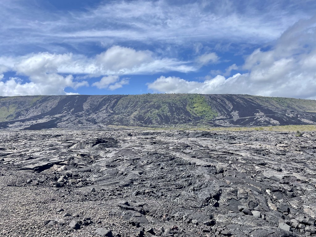
I stopped at a gas station for some snacks and drove south on Highway 11, (also known as Māmalahoa Highway or the Hawaiʻi Belt Road) top down, breeze blowing through my hair. Then it started to dump rain like only the Hawaiian Islands can do! Luckily it cleared up by the time I was at the very south tip of the island, which is also the most southern part of the United States. I stopped at mile marker 75 to take a look at the massive ancient lava fields from the eruption of Mauna Loa in 1907. 
Mauna Loa is one of the five volcanoes that form the Big Island and is also the largest active volcano on earth. She's sent lava flows across the road in this area in 1868, 1887, 1919, 1926, and 1950 also!
Up to this point, and after, the southern part of the island is so green and lush! The towns here are tiny, I drove through each in the blink of an eye.
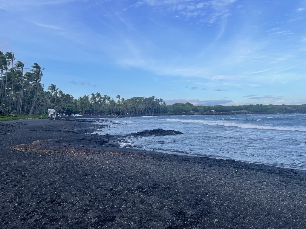
My next stop was at Punalu'u Black Sand Beach where there is usually a very high chance of seeing the resident honus swimming close to the shore. I didn't see any turtles though as it was crazy windy when I stopped! It is beautiful though!
30 minutes from here I reached Volcano House, the only hotel inside of Hawaii Volcanoes National Park, where I'd be staying for 2 nights.

I had booked a room with a view of Kīlauea's Halemaumau crater and was so excited to see the steam rising from it right from my bed! The hotel is rustic but cute; there are 2 gift shops, 2 restaurants, and absolutely amazing views of the crater. The Visitor's Center is just across the street, so if you are there you can walk over and take a look, you don't have to be a guest to come explore the hotel and its views.

That first night I ate at The Rim, the nicer of the two restaurants. My drinks and dinner were ok and as these are the only restaurants inside of the park, the prices were very inflated. But I was happy to take my wine to my room after dinner, just steps away vs driving home.
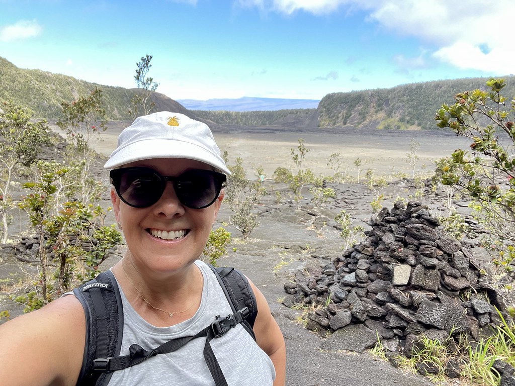
I only had 1 ½ days in the park and I had a lot I wanted to see and do, so the next morning I was out of the hotel at 8am and off to hike the Kīlauea Iki trail. I parked at the trailhead lot across from the Thurston Lava Tube and followed the trail counterclockwise, starting through a lovely rainforest with views of the crater floor below. Kīlauea's much larger crater can be seen in the distance.

This pit crater last erupted in 1959 and I could clearly see the trail on the crater floor that cuts straight across what was once a lake of molten lava! It was a little over a mile to the far end of the rim, then there was a 400 foot descent to the floor. The trail was very steep in parts; I followed the dirt path, stairs, and lots of volcanic rocks.
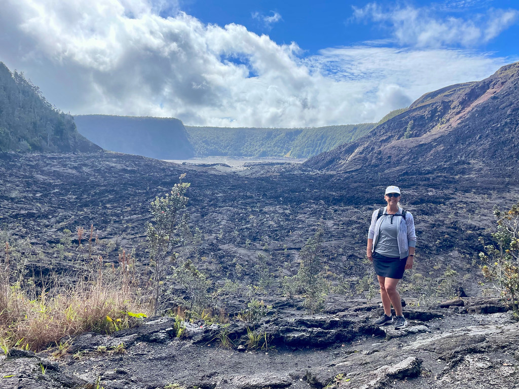
Now I had to get across the floor to the other side! It's very hard to make out the trail but I knew to follow the ahu (stone cairns) and stone markers. Even knowing that, they were hard to make out sometimes! Everything is varying shades of black with the random overachieving plant trying to break through. And the crust is very uneven with cracks that look like they can swallow you whole!

It was truly one of the coolest hikes I've done! It was like being on the moon, but with parts of it steaming! Once I got to the other side I still had to climb up another 400 feet to where my car was parked. The entire hike took me about 2 hours and was just over 3 ½ miles. I highly recommend this trail if you are in the area, it's like nothing else!
When I got back up to the parking lot, I crossed the road and entered the Thurston Lava Tube. Tubes like this are all over the islands, and once were the highway to 2000 degrees F molten lava!
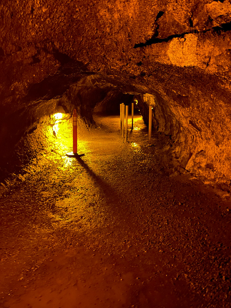
It's dark and creepy and totally cool!! Maybe not for people with claustrophobia however.
I hadn't been able to get a quick breakfast at the hotel before I left so I was very ready for lunch by this time. I drove to the Kilauea Lodge and had a really good brunch of their Volcano Loco (take on a Loco Moco) which came with house make pumpkin bread and coffee. It was a super cute dining room, with a big stone fireplace and really nice service.
Then I was back in the convertible and on the Chain of Craters Road. It's a 36-mile round trip drive down to the Pacific Ocean and back. There are no services on the road so it's important to have plenty of gas, snacks, and water!
The craters along the road were formed after magma below the earth receded (rather than by the eruption of a volcano) and the surface collapsed. One of the craters, Ko'oko'olau, hasn't seen lava in over 200 years and is now filled with greenery, while the others are quite barren.
Past the craters the road cuts through old lava flows all the way to the sea. It's pretty incredible to see the massive flows all around and imagine how it was when it was flowing!

The elevation goes from 4000 feet to sea level, and the road is very steep and twisty in sections. The views are just incredible! At mile marker 15.9 I came to my short hiking destination- the Pu'u Loa Petroglyph Field. There is parking on either side of the road and then it's just a short 3/4 of a mile walk out to the ancient stone carvings.

The Big Island has the most petroglyphs of the chain, and this particular field was just full of them. There's a boardwalk built around the field to keep people from destroying the artifacts. I find them fascinating!

Back on the road it was just 3 more miles to the sea. There wasn't any active lava when I visited but in years past you could come and watch the flow enter the ocean! That would be amazing! But the views of the Holei Sea Arch were still impressive, as is the force of the waves that crash against them. Sea arches like this are formed when lava is continuously pounded by the surf until it is undercut in the shape of an arch.

Time to turn the car around and head back to the hotel! Driving straight at the hills with clear sight of the lava flows was incredible!
It's just such an amazing area to explore! I spent about 3 hours on this road, taking time to stop to read about the various craters, lookouts, etc. Coupled with my morning hike, it was a long day and I was exhausted when I returned to Volcano House. Luckily they greeted me at the front desk with a complimentary mimosa which I enjoyed while I got cleaned up and ready for a casual dinner in the other restaurant Uncle George’s Lounge.


After checking out of Volcano House, I got my car, and drove over to the Kīlauea Overlook for some last views of the steaming crater. This is Hawaii's youngest and most active volcano and it doesn't seem like Goddess Pele is anywhere near done playing with it!
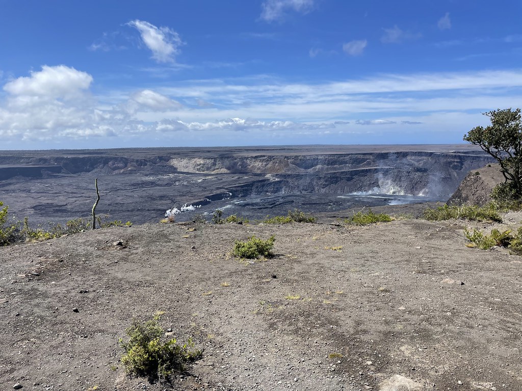
I took a short walk from here to Uekahuna, which is actually the chosen site that Native Hawaiians honor Pele. There are fantastic views of Mauna Loa, Kīlauea, and the old Jaggar Museum and Observatory. This had been on my list of places to visit in 2018 but unfortunately it sustained considerable damage during that eruption and is now being razed.

On my drive out of the park I decided to do one more short hike to Pu‘u Pua‘i. The parking lot is on the opposite side of Kīlauea Iki and it's just a mile out and back to see this odd mound of cinders that was formed during the eruption in 1959. The cinders were the result of 1,900 foot high lava fountains, cooling and falling back to earth, but today it just looks like a very barren hill.

And with that I said goodbye to this amazing national park and started my drive to the other side of the island!
All Big Island photos here.
Pre-Disaster Maui


No comments:
Post a Comment